Saturday, August 13, 2011

Long Island's Fishtail

The next destination on our eastward journey along Long Island Sound is the area known as the Fishtail of Long Island.  The far eastern end of the island splits into two forks or tails – the south fork stretches 40 miles from Riverhead to Montauk Point; the north fork stretches 30 miles from Riverhead to Orient Point.  Between the forks is a boater’s dream – deep bays, deep harbors, interesting towns for exploring and plenty of room for anchoring.

We got a late start from Port Jefferson for two reasons – one, there was air in the fuel line (again) and two, we were timing our arrival through Plum Gut for favorable currents.  Plum Gut, the route from Long Island Sound into Gardiners Bay, is a ¾- mile wide passageway separating Orient Point from Plum Island and the currents here can sometimes top 5 knots.  While the sound was choppy on July 30th, Plum Gut was calm.  As we cruised through, the Orient Point-New London ferry was making its way to the dock at Orient Point.

The nearby Plum Island is used by the Department of Agriculture for its Animal Disease Laboratory.  Researchers here study harmful insects and contagious animal diseases such as swine fever and hoof-and-mouth disease.  Since the island is strictly off-limits to visitors, rumors abound as to what really goes on here. Best-selling author Nelson DeMille wrote the murder-mystery Plum Island dealing with the fictional deaths of two of the island’s biologists.

We stayed clear of Plum Island (and all its intrigue) and made our way to Orient Harbor inside the north fork of the Fishtail.  We dropped the hook northeast of Long Beach Point in time for cocktail hour.  A kayak trip to the beach at Long Beach revealed a beachcomber’s paradise – a long, arching strand covered with smoothly rounded pebbles in beautiful muted colors and a vast assortment of cockle shells and monster-sized crab claws.  Buried somewhere beneath there must have been some sand but we did not see any!  The black flies were vicious and chased us back to Lazy W.

Part of our fleet beached at Long Beach

The cockle shells along Long Beach

Restored “bug” lighthouse in Gardiners Bay off Long Beach Point –
I don’t see it but to some people it looks like a water bug!

Across Gardiners Bay from Orient Harbor is Shelter Island, sometimes referred to as the jewel of the Fishtail.  One-third of the island’s 8,000 acres have been set aside as the Nature Conservancy’s Mashomack Nature Preserve.  The rest of the island is home to 2,500 year round residents and thousands more summertime visitors who make this place a popular tourist destination.  We moved Lazy W across the bay and carefully navigated the narrow channel that lead to a beautiful anchorage in Coecles Harbor.

The 38-foot Shelter Island Runabout is built at Coecles Harbor Marina and Boatyard.  Similar in appearance to a Hinckley Picnic Boat, the runabout was conceived by singer Billy Joel.  Joel, a Long Island native who years ago would swim out and ‘borrow’ other people’s moored boats off the North Shore, spent a lot of his adult free time sketching boats.  He envisioned a classic Down East lobster-style boat capable of cruising at 40 knots.  A naval architect translated his sketches into detailed blueprints and Peter Needham of Coecles Harbor Marine builds them. (The decks and hulls are molded in Maine and shipped to Shelter Island.)  Needham’s son Schuyler gave us a tour of the boat shed where workers were adding the finishing touches to a runabout.  We missed seeing Billy Joel by two days!!!

 Shelter Island Runabout under construction

The first Shelter Island Runabout was launched in 1996 and there are just over fifty in existence today.  They have been purchased by the famous – Woody Johnson, the NY Jets team owner has Endzone - and the infamous – Bernie Madoff once had Sitting Bull.  The starting price?  About $400,000...

A completed Shelter Island Runabout


That evening the smooth water of Coecles Harbor transformed into a swirl of white caps and the tranquil sky blazed with slashes of lightning.  A light rain fell.  There would be no stargazing that night.  But the following morning was a picture perfect summer day.  We launched the kayak and paddled along the Coecles Harbor Marine Water Trail which hugs the shore of the Mashomack Preserve.  To protect nesting shore birds, the landing of kayaks and dinghies is prohibited along the trail except at Taylor’s Island. The lone structure on this small island was built around the turn of the 20th century by Francis Marion Smith of 20-Mule Team Borax fame.  It is a small log cabin – obviously Mr. Smith was no Vanderbilt!  The original cabin was acquired and expanded by New York City hotel magnate S. Gregory Taylor in 1937 and bequeathed to the Town of Shelter Island in 1998.  It is listed on both the National and New York State Registers of Historic Places but, except for the slender tree trunks that serve as supports for the porch roof, it certainly does not appear to be anything special to me.


Coecles Harbor has a strictly enforced 48-hour mooring limit; dawdlers face a $250 fine.  It was time to move on to Brewer Yacht Yard at Greenport where Lazy W would get a much-needed bath and the pantry would be restocked before cruising to Sag Harbor.

Like Cold Spring Harbor on Long Island’s North Fork, Sag Harbor was a busy whaling port in the 1800’s.  And Long Wharf was the center of the action where the whaling ships were lined up six deep.  The streets of town were filled with businesses that served the trade.  The businesses disappeared with the whaling trade and many of the structures were destroyed by fires that ravaged the town in 1877.  However, many of the mansions owned by the whaling ship owners and captains still remain. 

 The entrance to the Sag Harbor Whaling Museum
whale jaw bones frame the front door
 

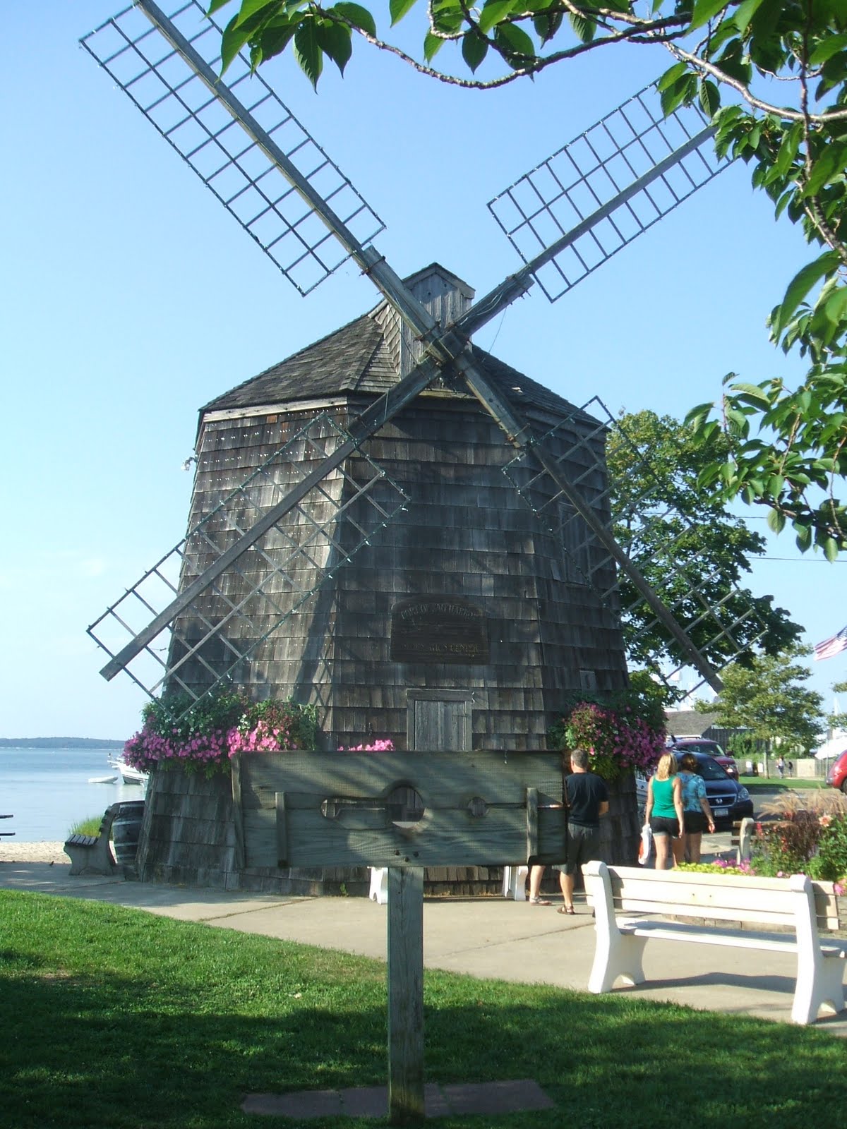
We anchored in Sag Harbor Cove and rode the dinghy into the town dock on Long Wharf.  An attractive windmill at the waterfront houses the Chamber of Commerce.  This is a replica of the Beebe Windmill that was built in Sag Harbor for Captain Lester Beebe.  In whaling days when a ship was sighted nearing the harbor, a flag was hoisted to the top of the windmill.  “Flag on the mill, ship in the bay” was the popular cry signaling the townspeople to throng to the wharf to see what ship was returning.

Operational windmills also functioned as community gathering places where people came together to socialize and exchange information while waiting for their grain to be "milled" or ground into flour. The prevailing off-shore breezes turned the blades of the windmill, powering the large gears enclosed in the building. The flat, open landscape of Long Island’s East End combined with these off-shore breezes made the area an ideal place for these early turbines.  The eleven windmills remaining on the eastern end of Long Island were built between 1795 and 1820.


Sag Harbor’s replica of the Beebe Windmill

Our search for the first Lobster Roll of the trip brought us to B. Smith’s Restaurant overlooking Sag Harbor Yacht Club.  B. (Barbara) Smith was the first African-American model to grace the cover of Mademoiselle in 1976.  She is known as an expert in affordable-yet-elegant living and is the proprietor of three restaurants – one in D.C.’s Union Station, one in New York City’s Times Square and one here in Sag Harbor.  While the Lobster Roll was fantastic the service was less than adequate.  Maybe if we had been part of the rich and famous crowd known to dine here we would not have had to go looking for someone to wait on us!  We missed Madonna by four days – she arrived at B. Smith’s by seaplane on Sunday...

Three Mile Harbor is the closest you can get by boat to East Hampton, the pricey summer retreat of the rich and famous.  The charge to dock your dinghy at one of the marinas here was a whopping $125 – but hey, you had access to their shower facilities and pool!  Needless to say we did not dock our dinghy here but instead found a spot at the East Hampton Town Dock and caught a cab to town.  Main Street was lined with pricey shops and high-priced performance cars – Maserati, Porsche, Ferrari, Aston Martin - were plentiful.

One of several Maserati’s parked along Main Street in East Hampton . . .

. . . and a nearby Aston Martin – left unlocked by its owner!

Stormy weather was looming on the horizon so after a stroll down Main Street to gawk at the cars and window shop we grabbed a quick drink at Sam’s Restaurant, hailed a cab and returned to reality aboard Lazy W.  And then the rain came; it rained so hard the galley cabinets leaked even though we were certain that we had plugged up that leak.

Since we had a rain delay – we were to return to Greenport to meet some friends – we used our down time to catch up on some reading.  While perusing the Real Estate section of The Southampton Press an ad for “an early entry beach front home in the happening town of Amagansett” caught my eye.  This four bedroom, three bath, two story home priced at $4,995,000 was described as “truly the best value on the ocean.”  Does this look like a $4.9 million dollar property?

$4,995,000

The deluge was over and it was time to raise anchor and cruise back over to Greenport where we would meet Rich and Terry Wills.  (We had unexpectedly met their daughter Beth while in Baltimore.)  Rich spent many a day of his youth at the family ‘fish house’ along Pipes Cove.  Frank and I had last been here in 1973 after a SUNY Maritime Spring Weekend.  No wonder that we had a difficult time spotting the ‘only brown house’ with ‘a block seawall’ along the cove!  By the time we had set our anchor Rich and Terry had arrived at the house we had picked out and we dinghied ashore to meet them.  It is always great to reconnect with old friends from college and this day was no exception.  We enjoyed a delicious lunch and wonderful conversation at Claudio’s Restaurant on the Greenport waterfront.  A trip to the tasting room at Pindar Winery topped off the day.  Much too soon it was time for Rich and Terry to catch the ferry from Orient Point back to New London and we headed out to reconnect with Lazy W gently swinging on the hook in Pipes Cove.


The following morning we left Pipes Cove by 8AM bound for Montauk.  Strangely enough there was not much boat traffic leaving Greenport or out on Gardiners Bay.  We noticed that it was a bit hazy and about five miles out we encountered the dreaded fog!  On no!  The fog horn was activated as we made our way through the fog bank.  Luckily we hit hazy sunshine before too long and the overcast skies followed us the rest of the way to Montauk. 

Fishing fleet in Montauk – New York’s largest fishing port


We planned to dock at Snug Harbor Marina but it soon became clear that Lazy W was just too big for their narrow fairways and short finger piers.  We backtracked to Montauk Marine Basin where we were directed to the long pier near the fuel dock – perfect.  We had lunch, unloaded the bikes and pedaled three miles to the village of Montauk and the beach.

Years ago this tip of Long Island was better known for its cattle ranching (Deep Hollow Ranch, the oldest cattle ranch in the United States was established here in 1658!) and freshwater fishing on Lake Wyandannee than as today’s tourist destination and angler’s paradise.  That is until 1926 when developer Carl G. Fisher envisioned Montauk as the “Miami Beach of the north.”  There was no EPA to contend with then so he blasted through a narrow spit of land that separated the lake from Long Island Sound.  Salt water Lake Montauk was born!  Now the base for over 150 charter fishing boats and numerous commercial vessels, it never became quite as ritzy or polished as Fisher envisioned it to be due in part to the Great Depression depleting his funds.

In 1898 when Lake Wyandannee was fresh water, Theodore Roosevelt watered his horses along its shore – maybe where Lazy W sits now!  Roosevelt and his Rough Riders and 29,000 other veterans of the Spanish-American War were quarantined at Montauk in an effort to keep the yellow fever-riddled troops form infecting the rest of the populace.

High upon the Turtle Hill bluff at Montauk Point sits the Montauk Point Lighthouse.  Its light is visible nineteen miles at sea.  Authorized by President George Washington in 1792, it was the first lighthouse built in New York.  We enjoyed spectacular Atlantic Ocean views after climbing its circular 137-step staircase to the fresnel lens lantern level.


Also on the bluff is the Lost at Sea Memorial honoring the 100+ fishermen of eastern Long Island who have been lost at sea.

Lost at Sea Memorial


Montauk Point declares itself the “surfcasting capital of the world’ but we never saw any surfcasters!  However, the charter boats back at Montauk Marine Basin were doing a brisk business, leaving the dock twice a day filled with hopeful fishermen intent on landing a trophy fish – tuna, marlin, swordfish and shark abound in the waters outside Lake Montauk.


Bluffs at Montauk Point


We thoroughly enjoyed our twelve days exploring Long Island’s fishtail but as the bumper stick says:


No comments:

Post a Comment