Tuesday, August 23, 2011

Rhode Island


Block Island, the “Bermuda of the North”

Block Island, Rhode Island is less than twenty miles from Montauk Harbor across Block Island Sound.  The island is shaped like a pork chop with Great Salt Pond nearly bisecting it.  A mile long and almost a mile wide, this is the favorite anchorage spot for the many boats that converge on Block Island from all directions.  In fact the Block Island website boasts dockage for over 400 boats, mooring space for 100 boats, and anchorage space for 1,000 boats.  When we arrived in the early afternoon of Thursday, August 11th, I believe we were boat number 1,001 looking for an anchorage spot!!


Great Salt Pond was filled with innumerable sailboats and powerboats, the 154-foot luxury yacht Ohana, the 164-foot mega yacht Imagine, the 123-foot luxury yacht Muse, the Mystic Whaler, the American Cruise Line’s American Star, and the Montauk-Block Island high-speed ferry Viking Superstar to name just a few.  We struggled to find a place to drop our anchor with adequate swing room for little Lazy W.  After dropping/raising/dropping the hook several times we were finally satisfied with our little piece of the pond and confident enough to go ashore via dinghy.

Champlin’s Marina and Resort provides a long finger pier for dinghy dockage.  We squeezed ours in and walked the docks thinking maybe we would have been better off springing for a slip at the marina.  Well the situation here was incredibly tight – It reminded us of Annapolis at boat show time!  Boats were docked gunwale to gunwale, bow to stern – and for this they were being charged $4.50/foot + $25 for electric!! 

The “parking lot” at Champlin’s Marina and Resort


Among the few small storefronts at Champlin’s Marina is Aldo’s Bakery.  Aldo’s Bakery looks like any other small town bakery/ice cream shop (except for the price of a single scoop cone - $4.25) but it provides a very unique service for the boaters crammed into Great Salt Pond – early morning and late afternoon delivery of fresh baked goods and sweets right to your boat via Boston Whaler!  Twice a day the rotund delivery man, accompanied by a teenage assistant, shouts “Andiamo! Andiamo!”  signaling his arrival amid the anchored boats.  Flag him down and chose from a variety of goodies.  It is quite reminiscent of the Caribbean where the locals swarm about the boats peddling their wares but with one big difference – Aldo’s is much cleaner, more upscale and much less aggressive!

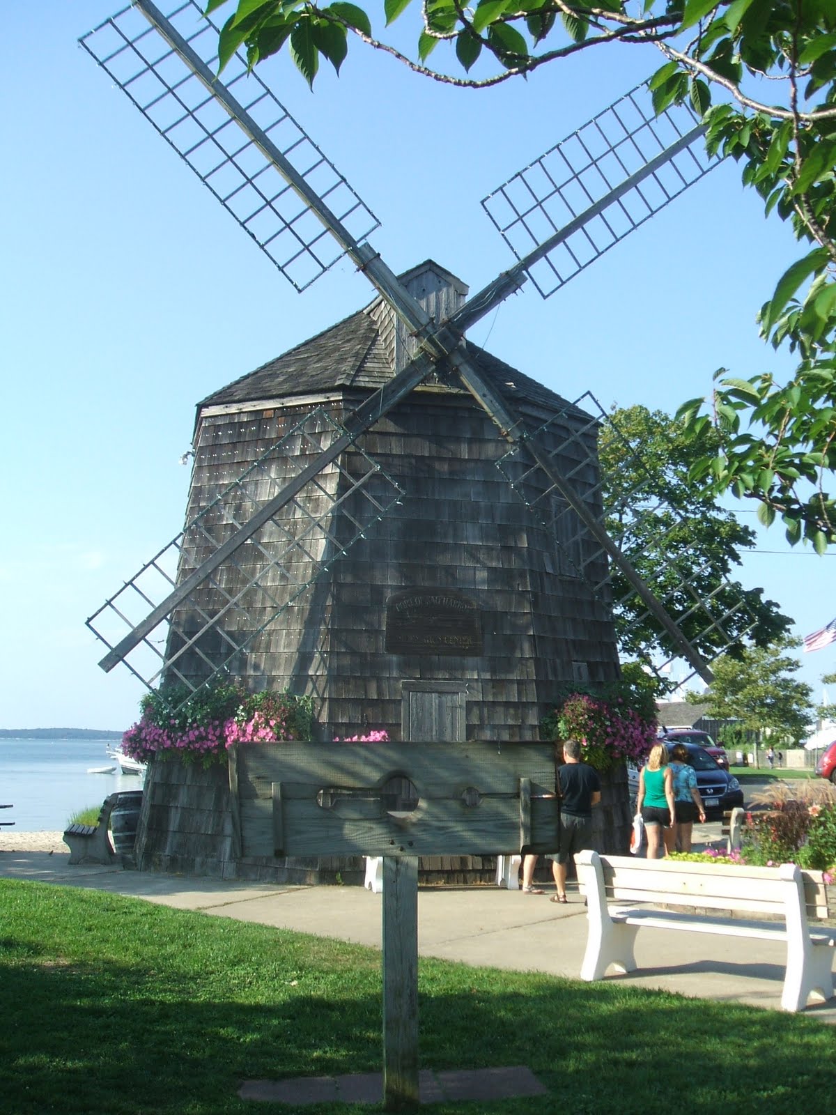
Aldo’s Bakery peddling baked goods in Great Salt Pond
the morning after most boats had the good sense to get out of the rain


The weather was picture perfect with temperatures in the 70’s, about 10 degrees cooler than mainland Rhode Island.  And while the moon that evening was too bright for stargazing, it was quite a sight to see all the boats’ anchor lights glowing against the darkening sky.


The best way to get from New Harbor (Great Salt Pond) to Old Harbor is by bike.  Getting our bikes on the dinghy would entail a precarious balancing act on our part so we opted to rent two bikes from Champlin’s Marina instead.  The young man in charge of bike and moped rentals was an exchange student from Macedonia who assured us that no point on the island is more than a twenty minute bike ride away. 

The shore side of Water Street in Old Harbor is lined with old but well-maintained Victorian hotels, shops that sell all things Block Island, restaurants and dozens of bike/moped rental kiosks.  We window shopped and clambered along the seawall for spectacular seascape views. And then the ferries from Connecticut and Rhode Island arrived at the docks of Old Harbor and disgorged their hundreds of tourists.  Suddenly the streets were brimming with folks of all ages wobbling along on rented bicycles vying with mopeds, taxis and delivery trucks for space on the crowded road. It was time to get out of town.

A ferry arrives in Old Harbor

 Southeast Lighthouse, one of two lighthouses on Block Island, was built in 1873.  It sits high atop Mohegan Bluffs and is said to be the brightest lighthouse on the Atlantic seaboard.  The bike ride from Old Harbor was all uphill and the pedaling was made more difficult than it should have been when the seat on my rented bike kept slipping downward.  Frank managed to tighten it and we finally made it to the picturesque lighthouse.

Block Island’s Southeast Lighthouse


Despite what our friend Jim Lancaster told us about every destination on the island “being uphill both ways,” the ride back to Champlin’s was mostly downhill but with a strong headwind.  We rewarded ourselves with lobster rolls at the Dockside Restaurant served to us by another exchange student from Macedonia.

As we were anchored in Great Salt Pond it became evident that we were beginning to experience electrical issues aboard Lazy W.  When Lazy W is docked at a marina, she is plugged into a power pedestal and all her electrical needs are met by the power company that supplies all landlubbers.  But when she is at anchor her electrical needs are met by a bank of two powerful house batteries.  These batteries are recharged when we are underway (just like the battery in a car) or by the generator and battery charger when we are at anchor for extended periods.  Running the battery charger twice a day for about two hours had been adequate for keeping the batteries at the desired voltage – until now!  The batteries were obviously nearing the end of their useful life and required recharging every few hours.  Without adequately charged batteries the refrigerator and lights would not be available for use.  These batteries are also used for starting Lazy W’s engines so it is really important that they be charged!  After much troubleshooting and phone calls, Frank located a source for new batteries in Providence, RI.  We endured two days of foul weather in Great Salt Pond before making our move to Brewer Yacht Yard’s Greenwich Bay Marina.


The best known attraction on Narragansett Bay may be Newport, Rhode Island.  But for us the best attraction would be Northeast Battery in Providence!  Narragansett Bay stretches eighteen miles from its entrance on Rhode Island Sound to the mouth of the Providence River; the state capital of Providence is another seven miles upriver.  We decided to cruise up the West Passage of the bay past Conanicut Island and Prudence Island to Greenwich Bay, tie Lazy W up at Greenwich Bay Marina and rent a car for the drive to Providence.

 Rhode Island coastline along Narragansett Bay

Dutch Island Light on Narragansett Bay
 

I neglected to mention that the house batteries are about the size of a small microwave, weigh about 150 pounds each, and are stored in a box in the engine room under the salon floor.  The ornery Captain was determined to prove that he could offload the drained batteries and reload the new ones without any help.  In a way that was a good thing because I certainly had no intention of getting involved with this potential fiasco.  However, if by chance, the Captain injured himself in the process, I would be the one to take care of him.  I warned him not to press his luck as nurse Barbara might not be as pleasant as she was last summer when he broke his ankle.  Nevertheless he persevered and, with the help of a strong back, dogged determination, and some creative rope/knot tying, he was able to heft the first acid-sloshing battery off the boat and into the back of the rented Nissan Cube.  We were off to Providence.  (Only the first of the two batteries made that trip to Northeast Battery as we wanted to be sure that the new ones were a perfect size match before hassling with the second one.)

Paul at Northeast Battery greeted us by name as we entered his storefront and before long the Nissan Cube was loaded with two new batteries at a cost of $700 – ouch, ouch, ouch!

Now that Frank had proven that he could singlehandedly wrestle with the batteries, he seemed more amenable to enlisting some help for the remainder of the process.  Troy, an able bodied guy from Brewer Yacht Yard, was willing to assist and the installation went smoothly.  With the second drained battery now in the Cube, we returned to Providence.

Since dockage rates are so steep in tony Newport we left Lazy W with her brand new house batteries in more-modestly priced Greenwich Bay and drove 25 miles to Newport.  Just as we missed seeing Billy Joel on Shelter Island and Madonna in Sag Harbor, we missed meeting Peg Morin in Newport by a week - such poor timing!

 Newport Harbor

Newport was the summer social capital of the nation during the Gilded Age (1865-1914).  The families who built ostentatious summer houses in this coastal city were leaders in national life amassing great industrial fortunes while influencing all aspects of American art, architecture, diplomacy, and business.  The Preservation Society of Newport County is the custodian of eleven of these historic properties with the goal of preserving and protecting Newport’s architectural heritage.  Some estates are still privately owned; others were bequeathed to educational institutions as is the case with Ochre Court.

Salve Regina University sits along Cliff Walk, a 3.5 mile walkway that hugs the rocky shore of Rhode Island Sound and the Atlantic Ocean.  Many of the great mansions of the Gilded Age were built here to take advantage of the beautiful water views.  Ogden Goelet, a noted banker, real estate investor and competitive yachtsmen, gifted his mansion in 1947 to the Religious Sisters of Mercy and Ochre Court is now the centerpiece of Salve Regina University, housing many administrative offices.  The campus is comprised of seven contiguous 19th century estates with 21 historic Gilded Age buildings.

Ochre Court, Salve Regina University

The grandest of Newport’s summer ‘cottages’ is The Breakers built by the Vanderbilt family  whose fortune was made in steamships and the New York Central Railroad, both of which played a pivotal role in the industrial growth of the United States in the late 19th century.  In 1893 Cornelius Vanderbilt II commissioned architect Richard Morris Hunt (who also designed the base for the Statue of Liberty) to design a seventy room Italian Renaissance-style palazzo inspired by the palaces of Genoa and Turin.  The 138,000 square foot mansion with a 2-1/2 story Great Hall, a Morning Room with platinum leaf wall panels, a billiards room with thick marble walls, 300 windows, 750 door knobs, 15 bedrooms, 20 bathrooms, innumerable Baccarat crystal chandeliers and wall sconces, and an overabundance of relief sculptures of cherubs, oak leaves and acorns took just two years to build and decorate.  Of course some of the rooms were designed and built in France, disassembled and shipped to Newport, where they were then fitted into the mansion!  We toured The Breakers and gawked in disbelief at the ornate decor before strolling back along the Cliff Walk to Narragansett Avenue and our humble rental car.

The Breakers

 We worked up quite an appetite and decided to have lunch at The Landing Restaurant on Bowen’s Wharf.  What a great place – not only did they offer wonderful views of the activity out in Newport Harbor but the clam chowder and seafood salad were outstanding.  Afterwards we roamed through Aquidneck Lobster to watch the lobstermen unload their tasty catch. 


Lobster Meat - $38/lb

We ended our day in Newport with a drive along Scenic Ocean Drive.  We were expecting to see dramatic ocean views but, for the most part, the views of the ocean were obscured by the large homes perched on the rocky shore.

After returning the rental car to Enterprise we bid farewell to Greenwich Bay Marina and headed northeast to Bristol Harbor.  Nestled between Popasquash Neck and Bristol Neck, the harbor had developed a considerable chop in the stiff afternoon southwesterly wind.  The closely moored boats rocked in a wild rhythm leaving little room for Lazy W.   Not relishing the thought of a rough night on the hook in such close quarters, we decided to check out Potter Cove, three miles southwest on the northern end of Prudence Island.  The water here was much calmer but unfortunately it was littered by unattended private mooring balls.  The fine for unauthorized use was reportedly $50.  Just outside the cove we found suitable space free of mooring balls and we settled in for the evening.

The Herreshoff Brothers, Nathanael and blind older brother John, started building boats in the town of Bristol in 1878.  Over the next seventy years the Herreshoff Manufacturing Company produced over 2,400 boats.  They only built boats of their own design and every part that went into the boat – anchors, cleats, engines, sails, etc. – was made on site.  The manufacturing campus is now home to the Herreshoff Marine Museum and America’s Cup Hall of Fame.  High speed launches, the U.S. Navy’s first torpedo boats Lightning and Stiletto, the catboat Sprite, the cruising yawl Belisarius are all on display along with hundreds of photos and memorabilia outlining the many accomplishments of the Herrreshoffs.   One of their most well-known accomplishments was the designing and building of seven successful America’s Cup defenders between 1893 and 1934, including 1903’s defender Reliance and 1992’s defender Defiant. 

 Defiant at the Herreshoff Marine Museum


The tree-lined streets of Bristol are bound by Federal-period stone building and 19th century homes lovingly maintained and used today as the town hall and visitor center, shops, restaurants and art galleries.  The center line running down High Street and Hope Street is painted a patriotic red, white and blue, marking the route of what is billed as the nation’s oldest Fourth of July parade.  (This year’s parade was #226.) 


After pizza at Bristol’s House of Pizza we strolled back to the dinghy dock where our dinghy was being battered by the wind and slamming into the wooden decking.  As happens each afternoon on Narragansett Bay, the prevailing southwesterlies were strengthening and the 1-2 foot waves, so benign from the deck of Lazy W, were poised to crash over the low-lying dinghy.  Oh well, it’s only water, salty water!  By the time we zigzagged through a sailboat race or two and pounded over the choppy waves back to Potter Cove, we and the dinghy were crusty form the salt spray.  Cocktail time!

For a change of scenery and better shelter from forecasted winds of 20+ knots) and heavy rain) we moved from Potter Cove to Kickamuit River where we spent another day on the hook.  From here Lazy W was just a few short miles from the Rhode Island/Massachusetts state line.  We thought that we might poke our bow over the line just to say we had cruised as far as Massachusetts.  The next day’s 3-5 foot seas on Rhode Island Sound kept these fair weather boaters on Narragansett Bay for another day.  So why not visit Fall River, MA?

Battleship Cove is dominated by the 608-foot battleship USS Massachusetts.  The museum headquartered here maintains fourteen mooring balls for visiting boaters and on this day they were all reserved for an incoming yacht club!  A skimpy anchorage area was bordered on two sides by menacing stone walls.  Oh well, a visit to the hometown of infamous Lizzie Borden (Lizzie Borden took an axe, gave her mother 40 whacks, when she saw what she had done, she gave her father 41) was not happening today.

Onward!  We proceeded south on the East Passage of Narragansett Bay passing Newport bound for our last possible anchorage on the bay – Mackerel Cove on Conanicut Island.  We did not want to venture out into Rhode Island Sound as the waves were running 3-5 feet.

Rose Island Light near Newport


We arrived at Mackerel Cove with some trepidation because none of our cruising guides mention anchoring here.   The long finger-like cove had many fine looking homes nestled among the trees high atop the rocky shore and a sandy beach at its far northern end. 

 At the entrance to Mackerel Cove

Throughout the afternoon we marveled at our good fortune to have found such a beautiful place to spend the night.  At one point in the day an impressive sailboat shared the cove with Lazy W.
 
At anchor in Mackerel Cove


As dusk approached the winds shifted.  Lazy W swung gently around and now the incoming waves from Rhode Island Sound buffeted our beam!  This rockin’ and rollin’ would continue throughout the night.  We now knew why this pretty cove was not recommended by any of the cruising guides – its mouth was wide open to Rhode Island Sound!

The morning of August 23rd was a pleasantly cool  59°. We pulled up anchor and headed to our last stop in Rhode Island – Point Judith.  We had been told that this was the place to stop for the cheapest diesel fuel in New England.  Yesterday’s rough seas on Rhode Island Sound had diminished to gentle rollers and we could not have asked for a more gorgeous day to be cruising.

Fishing on Rhode Island Sound


Point Judith Light


Point Judith is home to one of the largest commercial fishing fleets in New England and the Block Island ferry terminal.  Once inside the massive breakwater which creates the Harbor of Refuge, the channel runs between the villages of Galilee and Jerusalem; we turned to port and dropped over $1,000 on fuel in Galilee!  Then after spending four days on the hook we took a slip in Point Judith Marina for our last night in Rhode Island.


Saturday, August 13, 2011

Long Island's Fishtail

The next destination on our eastward journey along Long Island Sound is the area known as the Fishtail of Long Island.  The far eastern end of the island splits into two forks or tails – the south fork stretches 40 miles from Riverhead to Montauk Point; the north fork stretches 30 miles from Riverhead to Orient Point.  Between the forks is a boater’s dream – deep bays, deep harbors, interesting towns for exploring and plenty of room for anchoring.

We got a late start from Port Jefferson for two reasons – one, there was air in the fuel line (again) and two, we were timing our arrival through Plum Gut for favorable currents.  Plum Gut, the route from Long Island Sound into Gardiners Bay, is a ¾- mile wide passageway separating Orient Point from Plum Island and the currents here can sometimes top 5 knots.  While the sound was choppy on July 30th, Plum Gut was calm.  As we cruised through, the Orient Point-New London ferry was making its way to the dock at Orient Point.

The nearby Plum Island is used by the Department of Agriculture for its Animal Disease Laboratory.  Researchers here study harmful insects and contagious animal diseases such as swine fever and hoof-and-mouth disease.  Since the island is strictly off-limits to visitors, rumors abound as to what really goes on here. Best-selling author Nelson DeMille wrote the murder-mystery Plum Island dealing with the fictional deaths of two of the island’s biologists.

We stayed clear of Plum Island (and all its intrigue) and made our way to Orient Harbor inside the north fork of the Fishtail.  We dropped the hook northeast of Long Beach Point in time for cocktail hour.  A kayak trip to the beach at Long Beach revealed a beachcomber’s paradise – a long, arching strand covered with smoothly rounded pebbles in beautiful muted colors and a vast assortment of cockle shells and monster-sized crab claws.  Buried somewhere beneath there must have been some sand but we did not see any!  The black flies were vicious and chased us back to Lazy W.

Part of our fleet beached at Long Beach

The cockle shells along Long Beach

Restored “bug” lighthouse in Gardiners Bay off Long Beach Point –
I don’t see it but to some people it looks like a water bug!

Across Gardiners Bay from Orient Harbor is Shelter Island, sometimes referred to as the jewel of the Fishtail.  One-third of the island’s 8,000 acres have been set aside as the Nature Conservancy’s Mashomack Nature Preserve.  The rest of the island is home to 2,500 year round residents and thousands more summertime visitors who make this place a popular tourist destination.  We moved Lazy W across the bay and carefully navigated the narrow channel that lead to a beautiful anchorage in Coecles Harbor.

The 38-foot Shelter Island Runabout is built at Coecles Harbor Marina and Boatyard.  Similar in appearance to a Hinckley Picnic Boat, the runabout was conceived by singer Billy Joel.  Joel, a Long Island native who years ago would swim out and ‘borrow’ other people’s moored boats off the North Shore, spent a lot of his adult free time sketching boats.  He envisioned a classic Down East lobster-style boat capable of cruising at 40 knots.  A naval architect translated his sketches into detailed blueprints and Peter Needham of Coecles Harbor Marine builds them. (The decks and hulls are molded in Maine and shipped to Shelter Island.)  Needham’s son Schuyler gave us a tour of the boat shed where workers were adding the finishing touches to a runabout.  We missed seeing Billy Joel by two days!!!

 Shelter Island Runabout under construction

The first Shelter Island Runabout was launched in 1996 and there are just over fifty in existence today.  They have been purchased by the famous – Woody Johnson, the NY Jets team owner has Endzone - and the infamous – Bernie Madoff once had Sitting Bull.  The starting price?  About $400,000...

A completed Shelter Island Runabout


That evening the smooth water of Coecles Harbor transformed into a swirl of white caps and the tranquil sky blazed with slashes of lightning.  A light rain fell.  There would be no stargazing that night.  But the following morning was a picture perfect summer day.  We launched the kayak and paddled along the Coecles Harbor Marine Water Trail which hugs the shore of the Mashomack Preserve.  To protect nesting shore birds, the landing of kayaks and dinghies is prohibited along the trail except at Taylor’s Island. The lone structure on this small island was built around the turn of the 20th century by Francis Marion Smith of 20-Mule Team Borax fame.  It is a small log cabin – obviously Mr. Smith was no Vanderbilt!  The original cabin was acquired and expanded by New York City hotel magnate S. Gregory Taylor in 1937 and bequeathed to the Town of Shelter Island in 1998.  It is listed on both the National and New York State Registers of Historic Places but, except for the slender tree trunks that serve as supports for the porch roof, it certainly does not appear to be anything special to me.


Coecles Harbor has a strictly enforced 48-hour mooring limit; dawdlers face a $250 fine.  It was time to move on to Brewer Yacht Yard at Greenport where Lazy W would get a much-needed bath and the pantry would be restocked before cruising to Sag Harbor.

Like Cold Spring Harbor on Long Island’s North Fork, Sag Harbor was a busy whaling port in the 1800’s.  And Long Wharf was the center of the action where the whaling ships were lined up six deep.  The streets of town were filled with businesses that served the trade.  The businesses disappeared with the whaling trade and many of the structures were destroyed by fires that ravaged the town in 1877.  However, many of the mansions owned by the whaling ship owners and captains still remain. 

 The entrance to the Sag Harbor Whaling Museum
whale jaw bones frame the front door
 

We anchored in Sag Harbor Cove and rode the dinghy into the town dock on Long Wharf.  An attractive windmill at the waterfront houses the Chamber of Commerce.  This is a replica of the Beebe Windmill that was built in Sag Harbor for Captain Lester Beebe.  In whaling days when a ship was sighted nearing the harbor, a flag was hoisted to the top of the windmill.  “Flag on the mill, ship in the bay” was the popular cry signaling the townspeople to throng to the wharf to see what ship was returning.

Operational windmills also functioned as community gathering places where people came together to socialize and exchange information while waiting for their grain to be "milled" or ground into flour. The prevailing off-shore breezes turned the blades of the windmill, powering the large gears enclosed in the building. The flat, open landscape of Long Island’s East End combined with these off-shore breezes made the area an ideal place for these early turbines.  The eleven windmills remaining on the eastern end of Long Island were built between 1795 and 1820.


Sag Harbor’s replica of the Beebe Windmill

Our search for the first Lobster Roll of the trip brought us to B. Smith’s Restaurant overlooking Sag Harbor Yacht Club.  B. (Barbara) Smith was the first African-American model to grace the cover of Mademoiselle in 1976.  She is known as an expert in affordable-yet-elegant living and is the proprietor of three restaurants – one in D.C.’s Union Station, one in New York City’s Times Square and one here in Sag Harbor.  While the Lobster Roll was fantastic the service was less than adequate.  Maybe if we had been part of the rich and famous crowd known to dine here we would not have had to go looking for someone to wait on us!  We missed Madonna by four days – she arrived at B. Smith’s by seaplane on Sunday...

Three Mile Harbor is the closest you can get by boat to East Hampton, the pricey summer retreat of the rich and famous.  The charge to dock your dinghy at one of the marinas here was a whopping $125 – but hey, you had access to their shower facilities and pool!  Needless to say we did not dock our dinghy here but instead found a spot at the East Hampton Town Dock and caught a cab to town.  Main Street was lined with pricey shops and high-priced performance cars – Maserati, Porsche, Ferrari, Aston Martin - were plentiful.

One of several Maserati’s parked along Main Street in East Hampton . . .

. . . and a nearby Aston Martin – left unlocked by its owner!

Stormy weather was looming on the horizon so after a stroll down Main Street to gawk at the cars and window shop we grabbed a quick drink at Sam’s Restaurant, hailed a cab and returned to reality aboard Lazy W.  And then the rain came; it rained so hard the galley cabinets leaked even though we were certain that we had plugged up that leak.

Since we had a rain delay – we were to return to Greenport to meet some friends – we used our down time to catch up on some reading.  While perusing the Real Estate section of The Southampton Press an ad for “an early entry beach front home in the happening town of Amagansett” caught my eye.  This four bedroom, three bath, two story home priced at $4,995,000 was described as “truly the best value on the ocean.”  Does this look like a $4.9 million dollar property?

$4,995,000

The deluge was over and it was time to raise anchor and cruise back over to Greenport where we would meet Rich and Terry Wills.  (We had unexpectedly met their daughter Beth while in Baltimore.)  Rich spent many a day of his youth at the family ‘fish house’ along Pipes Cove.  Frank and I had last been here in 1973 after a SUNY Maritime Spring Weekend.  No wonder that we had a difficult time spotting the ‘only brown house’ with ‘a block seawall’ along the cove!  By the time we had set our anchor Rich and Terry had arrived at the house we had picked out and we dinghied ashore to meet them.  It is always great to reconnect with old friends from college and this day was no exception.  We enjoyed a delicious lunch and wonderful conversation at Claudio’s Restaurant on the Greenport waterfront.  A trip to the tasting room at Pindar Winery topped off the day.  Much too soon it was time for Rich and Terry to catch the ferry from Orient Point back to New London and we headed out to reconnect with Lazy W gently swinging on the hook in Pipes Cove.


The following morning we left Pipes Cove by 8AM bound for Montauk.  Strangely enough there was not much boat traffic leaving Greenport or out on Gardiners Bay.  We noticed that it was a bit hazy and about five miles out we encountered the dreaded fog!  On no!  The fog horn was activated as we made our way through the fog bank.  Luckily we hit hazy sunshine before too long and the overcast skies followed us the rest of the way to Montauk. 

Fishing fleet in Montauk – New York’s largest fishing port


We planned to dock at Snug Harbor Marina but it soon became clear that Lazy W was just too big for their narrow fairways and short finger piers.  We backtracked to Montauk Marine Basin where we were directed to the long pier near the fuel dock – perfect.  We had lunch, unloaded the bikes and pedaled three miles to the village of Montauk and the beach.

Years ago this tip of Long Island was better known for its cattle ranching (Deep Hollow Ranch, the oldest cattle ranch in the United States was established here in 1658!) and freshwater fishing on Lake Wyandannee than as today’s tourist destination and angler’s paradise.  That is until 1926 when developer Carl G. Fisher envisioned Montauk as the “Miami Beach of the north.”  There was no EPA to contend with then so he blasted through a narrow spit of land that separated the lake from Long Island Sound.  Salt water Lake Montauk was born!  Now the base for over 150 charter fishing boats and numerous commercial vessels, it never became quite as ritzy or polished as Fisher envisioned it to be due in part to the Great Depression depleting his funds.

In 1898 when Lake Wyandannee was fresh water, Theodore Roosevelt watered his horses along its shore – maybe where Lazy W sits now!  Roosevelt and his Rough Riders and 29,000 other veterans of the Spanish-American War were quarantined at Montauk in an effort to keep the yellow fever-riddled troops form infecting the rest of the populace.

High upon the Turtle Hill bluff at Montauk Point sits the Montauk Point Lighthouse.  Its light is visible nineteen miles at sea.  Authorized by President George Washington in 1792, it was the first lighthouse built in New York.  We enjoyed spectacular Atlantic Ocean views after climbing its circular 137-step staircase to the fresnel lens lantern level.


Also on the bluff is the Lost at Sea Memorial honoring the 100+ fishermen of eastern Long Island who have been lost at sea.

Lost at Sea Memorial


Montauk Point declares itself the “surfcasting capital of the world’ but we never saw any surfcasters!  However, the charter boats back at Montauk Marine Basin were doing a brisk business, leaving the dock twice a day filled with hopeful fishermen intent on landing a trophy fish – tuna, marlin, swordfish and shark abound in the waters outside Lake Montauk.


Bluffs at Montauk Point


We thoroughly enjoyed our twelve days exploring Long Island’s fishtail but as the bumper stick says:


Sunday, August 7, 2011

For the engineers among us from the engineer aboard

Contrary to some people’s belief (John Grubbs :), Lazy W does not get its name from the work habits of her Admiral or Captain.  Rather it is a reference to the constellation Cassiopeia, the Lazy W.  Cassiopeia was our first choice for a boat name but neither of us wanted to have to spell that mouthful (actually we could not spell it!!) when making marina reservations over the VHF, thus Lazy W.


And now, by popular request, here is some information on Lazy W for the engineers in the reading audience.
 
Questions have arisen concerning the electronics onboard.  Here is a quick rundown of the electronics at the upper helm.


Port side electronics

Furuno Echo Sounder Fish Finder (LS-6100) – gives us water depth, latitude/longitude position, speed, and course.  However, the speed gauge never registers above 0.0 knots thus confirming my opinion that Lazy W is indeed a very slow boat!

Standard Horizon GPS/Chart Plotter (CP390i) – new for this trip.  Has now developed an attitude – when turned on it freezes up, beeps and won’t allow itself to be turned off!  The Admiral has to go below and turn off the bridge circuit breakers.  The Captain then makes many attempts to cajole it into restarting which it eventually does.  Many phone calls to tech support over the past few weeks.  Each time a software update is loaded the chart plotter develops new problems.  She was sent on a cross-country trip to CA for repairs and when she returned she was still not working correctly.  We are still dealing with her issues and with tech support.

Also visible are the bow thruster joy stick and the engine gear shift controls.


Starboard side electronics

JRC LCD Color Radar Plotter 1800 – held up our departure from Portsmouth while it was out for repairs in Seattle.  It now works fine.

Throttle Controls (red knobs)

Furuno Nav Pilot – our last boat, Sea Venture, did not have auto pilot capabilities.  We have grown to love this feature of Lazy W.
 
Datamarine Depth Gauge – probably original equipment.  It is a repeater gauge for the lower helm equipment.

We have a Standard Horizon DSC VHF Radio (not visible) and a Danforth Constellation compass (recently reworked by W.T. Brownley).


Center helm – the many gauges we monitor throughout the cruise


Now for the main plant!!!  All of this is underneath the salon floor.  This is Frank’s territory – the comments are his.

Here is the through cabin sole access – provided by a re-worked aluminum stepladder:


________________________________________________________

Of course once you are in the Engine Room, you can see, smell and hear all sorts of equipment:

·          Battery switch

·          8D Batteries

·          Halon Engine Room Fire Extinguisher

·          Inverter

·          Aft head plumbing :-)


_______________________________________________________

·          Gulf Fuel Oil polishing filter

·          Top of Port Lehman engine


________________________________________________________________________________________________


·          Racor primary Fuel oil Filters

·          Air Conditioning water hoses

·          Main Engine Sea Strainer


 _________________________________________________________________

·          Sound enclosure for the 10kw generator


_________________________________________________________


·          Hot Water Heater

·          Fresh Water Filter, gage and pressure switch

·          Fuel Oil Supply Manifold


________________________________________________________


·          Overboard Discharge lines with siphon breakers

·          Generator Battery Selector Switch


_________________________________________________________


·          The forward air conditioner controls

·          The Reverse Osmosis water maker

·          More overboard discharge lines


The main engines are Ford/Lehman diesels.  These naturally aspirated engines are the same displacement as the Yanmar engines on our previous boat, Sea Venture, about twice the weight and half the horsepower!!!!  They are fine for propelling the Lazy W at hull speed (8 knots).  At hull speed we get about 2 nautical miles per gallon (half the fuel consumption of Sea Venture).  However, efficiency declines when the Admiral wants to water ski, and we push her to the blazing speed of 9 or 10 knots. Lazy W rolls more than Sea Venture - largely due to hull shape.  The hull flattens aft and she has chines which help her roll less than other boats we considered.
 
She carries 500 gallons of fuel (ouch!), 250 gallons of water, a huge quantity of food and alcohol plus the two of us!!!