Friday, July 15, 2011

Cape May to Atlantic City

Cape May has always been a favorite stopover of mine on our way north/south along the New Jersey coast.  From our slip at Utsch’s Marina it is just a short stroll to the Lobster House to pickup fresh scallops and the homemade soup of the day for preparation on Lazy W.  A leisurely bike ride down Lafayette Street brings you to Beach Avenue which follows the line of dunes fronting the shoreline.  All along the way are the grand ‘painted ladies’ from the late nineteenth century lovingly restored into B&B’s, guest houses and private homes.  The city of Cape May has more of these Victorian structures than any other place in the country and in 1976 the city was designated a National Historic Landmark District.


Along Beach Avenue


The beach promenade was hosting a small art fair and we perused the photographs and watercolors before crossing the walkway over the dunes to the beach.  And we were able to do this without purchasing a ‘beach tag’ which was needed later on that morning when ‘beach tag enforcers’ controlled access to the beach.


We departed Cape May Harbor on July 11th.  Just as we reached the Atlantic Ocean we were surprised to see a lone female paddleboarder about one mile offshore – not another soul around her and we thought, how dangerous is that?  Later on while reading The Press of Atlantic City we realized that she was Margo Pellegrino, a 44-year-old mother of two, who is an expert stand-up paddleboarder.   We saw her getting started on her quest to become the first person to do a non-stop paddleboard excursion from Cape May to Sandy Hook – 127 miles!  Why? To raise money for Children’s Hospital of Pennsylvania.  She expects to arrive in Sandy Hook sometime tomorrow afternoon, 30 hours after leaving Cape May.  And we thought we were adventurous!!

There is not much happening out in the Atlantic off the Jersey coast.  We followed the long white ribbon of sand from about two miles out.  A few pods of dolphin, several parasailers off Wildwood and an occasional fishing excursion boat were all that kept us company until the casino towers of Atlantic City came into view.  It was time to brace ourselves for entry into busy Absecon Inlet.


Atlantic City Coast Guard Station


Rather than pay exorbitant marina fees at the Trump-managed Farley State Marina we returned to a favorite anchorage in a basin just off Rum Point.  The only problem with this anchorage is getting there – the water leading to it is very shallow.  As we entered I could see fishermen standing in waist-deep water just a few feet off Lazy W’s starboard side but Frank bravely hugged the portside muddy flats.  There were no other boats anchored in the basin and we picked a choice spot in twelve feet of water.  A nice refreshing breeze kept us comfortable but would later prove to be a BIG problem.


Borgata’s, The Water Club and Harrah’s from our Atlantic City anchorage
(note the wind turbines to the right)


As darkness enveloped the anchorage, the entire wavy-top building behind Harrah’s transformed into a huge, garish electronic billboard! 

WORLD SERIES OF POKER!


HANGOVER SLOTS!


CASH SPIN!

HOLY GUACOMOLE

 AUTHENTIC MEXICAN CUISINE AND TEQUILA!

HANG OUT AT THE RED DOOR SPA!

And then the gentle breeze turned on us and blew at 20-25 knots with gusts of 30 knots.  By midnight we were dragging anchor and drifting perilously close to some small boat piers.  With adrenaline pumping, we sprang into action with a plan to reset the hook.  I donned a life jacket and fought my way (literally) through the wind to reach the bow pulpit while Frank started the engines.  I undid the bridle and raised the muddy anchor as Frank motored Lazy W further out into the basin where we let out 125 feet of anchor chain.  More than an hour later we convinced ourselves that the wind was calming down and the anchor was holding.  Too keyed up to sleep we made breakfast and wondered aloud how Margo Pellegrino, the paddleboarder, was faring in these conditions.

The same blustery winds that caused us to drag anchor forced Margo Pellegrino ashore at 3AM at Ship Bottom on Long Beach Island.  She had paddled beyond Atlantic City!  While she had planned to continue her trek up the Jersey coast at sunup, weather conditions were not ideal.  However, she managed to paddle as far as Seaside Heights (north of Barnegat Inlet) before abandoning her quest to reach Sandy Hook.  She told a reporter, “At best we would have been a Coast Guard rescue, and at worst we would have been dead.”  Undaunted, Margo plans to attempt the 127-mile paddle again someday.  Her current effort raised $2,300 for childhood cancer research. 

While Margo was paddling toward Seaside Heights, we listened to marine forecasts and decided to stay at anchor for another day awaiting more favorable seas for the remaining 90 mile cruise to Sandy Hook.  We dinghied across Absecon Inlet and stopped in at the Farley State Marina for ice.  The dock hand there informed us that docking fees were now half the price we remembered them being in 2002!  We could have been tied securely to a dock instead of dragging anchor halfway across the Rum Point basin!!  “And what fun would that have been?” asked the Captain.


Sunday, July 10, 2011

On to Cape May, New Jersey

Baltimore’s Waterfront Promenade is a seven mile long sidewalk that connects the historic communities of Canton, Fells Point and Federal Hill to the Inner Harbor.  Future plans call for an extension that will reach to Fort McHenry.  The wide brick path zigzags along the waterfront over what were once crumbling piers and rotting warehouses, replaced now by open green spaces and modern condos.  Anchorage Marina sits on the Canton end of the promenade and if the weather had not been so hazy, hot and humid we most likely would have walked or biked our way to the Inner Harbor; we walked the path into Fells Point before turning back to the air conditioned comfort of Lazy W where we awaited the start of the 4th of July fireworks.

As showtime neared, a sprinkling of rain drops began to fall but that did not dampen the spirits of the many partiers on the marina docks.  The fireworks display got underway at 9:30 and 18 minutes later the grand finale brought cheers and horn blasts from the flotilla of boats idling in the Patapsco River.  While Baltimore was purported to have the biggest fireworks display in the mid-Atlantic region, I for one thought that previous Norfolk displays over the Elizabeth River had this one beat!

We unexpectedly spent another day in Baltimore after Frank’s routine check of the engine room detected a leak in the air conditioner fittings.  The plastic connectors that screw into the copper fittings had hairline cracks and were allowing water to drip into the bilge.  With a gleam in his eyes, Frank scrambled into action, removed the fittings, pried out the plastic stuff and headed off to the nearby West Marine to purchase replacement parts.  The repair itself did not take that long but the cleanup of the bilge turned into an all day affair.
 
The weather continued its hazy, hot and humid streak; the haze was so thick that it obscured the Francis Scott Key Memorial Bridge as we made our way back to the Chesapeake Bay bound for Georgetown, eight miles up the Sassafras River.  The guidebooks tout the river, named for the sassafras trees along its banks, for its scenic beauty and the villages of Georgetown and Fredericktown for their vibrant charm.  While the river is beautiful, there is not much to the villages except marina after marina after marina.  The dockmaster at Sailing Associates pointed us over the Route 213 bascule bridge, up the hill and, after a mile-plus hike, he assured us we would arrive in the town of Galena.  With temperatures already nearing 90° I was pretty sure I did not need an ice cream cone so badly that I was willing to trek to Galena, so we had an enjoyable lunch in the only cafĂ© open for business in Fredericktown – one of only two businesses we saw in the village!
 
By now we had spent over three weeks cruising up the Chesapeake Bay from Portsmouth - it was time to move Lazy W on up to the C&D Canal.  We pulled up the hook on July 8th and prepared to leave the Sassafras River behind.  At the northern end of the mouth of the Sassafras as we rounded Grove Point a mammoth southbound commercial vessel, the roll-on/roll-off Miraculous Ace, loomed ahead.  We gave it plenty of room in the channel to safely pass us.
 

A canal linking the Chesapeake and Delaware bays was first envisioned by Auguste Hermann in the 17th century.  But it wasn’t until 1829 that the canal opened to ship traffic.  It took seven years and the backbreaking labor of 2,600 men to build the original canal which was ten feet deep and sixty-six feet wide.  There have been several expansions since 1919 when the United States government purchased the canal.  Its current depth is maintained at thirty-five feet and its width is four hundred feet.  Six bridges span its 14-mile length and bulky riprap lines its bank.
 
The traffic light at Town Point Neck, the western entrance of the C&D Canal along the Elk River was green, signaling that the canal was open to traffic.  This would be our fourth time traversing the canal and we are convinced that the sun never shines here!  Gloomy skies, sweltering heat and oppressive humidity were once more the order of the day.  While the canal is typically busy with tankers and barges, on this day pleasure boats definitely outnumbered commercial vessels.

 Approaching Chesapeake City Bridge under gloomy skies
 
We typically make an overnight stop at the docks in Chesapeake City but earlier arrivals there and in the anchorage basin crowded us out.  I pled my case for power and full A/C; the Captain agreed that a cool night in a marina would be preferable to a night on the hook so we continued east on the canal to Summit North Marina in Bear, Delaware.  The marina, on the north shore of the canal tucked in a basin that was dug in 1966 in an attempt to straighten the canal (that plan was later abandoned), still bears the scars from 2003’s Hurricane Isabel – grotesquely twisted floating finger piers!  Lazy W was assigned a slip with a relatively flat finger pier and we were quite satisfied to plug in, crank up the A/C and cool off – AAH!  But alas, around 2:30 thunder boomers rolled overhead, torrential rain fell and the power throughout the marina went out.  Luckily the outage was short-lived...

The rain did eventually stop but not before causing major headaches for many portions of the states of Delaware, Pennsylvania and New Jersey.  We woke to hazy, calm conditions and finished transiting the C&D Canal shortly after 7AM.  There was very little traffic along the way – one eastbound sailboat and one westbound tug/barge combination – between Summit North Marina and the end of the canal on the Delaware Bay.

It was now time to face the long southbound trek down the wide open water of the Delaware Bay. Frank had skillfully timed our arrival on the bay so that we could take full advantage of the tidal currents (as much as 4 knots) for at least the first half of the 46-mile trip to Cape May, NJ.  He did such a great job that we reached a speed of 10.7 knots as we approached Ship John Shoal Light – woo hoo!  No trip down the bay is complete without taking a picture of the impressive Salem Nuclear Power Plant where Frank spent so much time in the early 1990’s.


Salem Nuclear Power Plant on the Delaware Bay

Many deep-draft commercial vessels were plying the shipping channels of the Delaware Bay; small fishing boats were bobbing in the ensuing wakes.  And the sun was shining! 
 
 Commercial traffic along the Delaware Bay

As we neared the entrance to the Cape May Canal, the Cape May-Lewes ferries were on the move – one going out and one coming in.  We politely let them finish their maneuvers before entering the canal.  Just on the other end of the canal is the very friendly and welcoming Utsch’s Marina where we took on 270 gallons of diesel fuel (ouch!) – no wonder the staff was so friendly!  We had arrived safely at one of my favorite places – Cape May, NJ.


Monday, July 4, 2011

4th of July in Baltimore

Leeds Creek is only a short two mile dinghy ride across the Miles River from the St. Michaels harbor but it seems like a world away.  The harbor is ringed by waterfront seafood restaurants and marinas hosting all manner of vessels, from the well-worn workboats of the crabbers to trawlers and luxury yachts to the American Cruise Line’s American Glory.  Leeds Creek, on the other hand, is home to osprey and great blue heron and a few ostentatious mini-mansions peeking out from behind the wooded shoreline.  While we enjoyed the amenities of St. Michaels – happy hour at Characters CafĂ©, wine tasting at St. Michaels Winery, and the ease of provisioning at the local Acme Supermarket – we certainly appreciated the serenity of Leeds Creek from which we could watch the Wednesday night sailboat races and gaze at the star-studded evening sky.  The lights of Norfolk and Portsmouth obscure the night sky so it was a real treat to observe the dazzling array of stars and constellations here; the Big Dipper and Cassiopeia (aka Lazy W) were clearly visible overhead.  The occasional splashes of leaping fish slapping the water were the only sounds in the night.

After five days (yes, 5 days!) in Leeds Creek it was time to move on.  We somewhat reluctantly pulled up anchor and were underway at 5:45AM on July 2nd bound for Baltimore.  The sun was just clearing the treetops but the watermen were already hard at work.


We arrived at Kent Narrows near high tide and had trouble contacting the bridge tender for the bascule bridge on the VHF.  We strained to locate the telephone number on the bridge house; we finally reached the sleepy-sounding tender and he let us through the bridge at the 7:30 opening.  The Narrows is a well-marked channel but the north end is very, very narrow and very, very shallow.  Frank expertly guided us through the passage as I snapped this osprey couple tending their new family atop the day marker.


What better place to spend the 4th of July holiday weekend than Baltimore!  After all, this is the place where Francis Scott Key penned the words to The Star Spangled Banner during the War of 1812.  There is even a very unique buoy in the harbor just past the Key Memorial bridge marking the spot where Key watched the British bombardment of Fort McHenry on the night of September 13, 1814. At dawn he was able to see the American flag still fluttering above the fort and he was inspired to write a poem describing his experience.  This poem was later adopted as our national anthem.  The red, white and blue buoy is the only one of its kind and has been put in place by the United States Coast Guard each boating season since 1972.  It is removed each fall to protect it from ice damage and for refurbishment for the next year.


Shortly after passing the Francis Scott Key buoy we found the Anchorage Marina and were tied up to the outer dock by 11:30.  We took care of several chores and shopped at the nearby Safeway in anticipation of the arrival of our son and grandson, Brian and Cameron.  The marina is located outside the Inner Harbor and the guys were unwittingly faced with a 25-minute walk in the heat and humidity from their parking spot to the boat!


Next morning Cameron convinced Grandpa that it would be more fun to take the dinghy to the Inner Harbor than to hop aboard the water taxi.  The Wiegand guys are big fellas and with all of us aboard the dinghy we were just under her posted weight limit capacity.  We bravely made our way through the Inner Harbor avoiding the Urban Pirates aboard Fearless who threatened to blast us with their mighty water cannons.  The dinghy dock near the USS Constellation was full so we found docking space near the Seadog speed boats.


Since Cameron played  baseball this season we thought a tour of Orioles Park at Camden Yards would be a nice way to spend an afternoon in Baltimore.  Our tour guide regaled the adults with historical facts about the history and renovation of the B&O Warehouse, sports trivia and anecdotes while ushering us through the many behind-the-scenes areas that few fans get to see – VIP lounges and club level suites, media rooms, and the scoreboard control room – before finally arriving at the Orioles dugout.  By now, Cameron had tired of the long talkathon tour (the adults thought it was great) but he perked up when the tour guide recruited his assistance in passing out post cards and key chains.  Ice cream at the Inner Harbor was his well-earned reward!


Anyone who has spent any time on the Chesapeake Bay knows that the blue crab rules!  Its likeness is embroidered on T-shirts and aprons, painted on mugs and Christmas ornaments, displayed on packaging for everything from spices to teas.  We even saw bags of little chocolates labeled crab poop!  This sign in a shop in Harborplace caught our eye.


Across Boston Street from the Anchorage Marina is a very nice shopping center with several eateries.  We all agreed that pizza sounded like a good dinner choice and Pasticcio Italian Kitchen was the place to go.  We were amazed to meet Beth and Jonathan Cho having dinner there!  We knew they lived somewhere in Baltimore but what were the odds that of all the restaurants in this city we would all be dining in Pasticcio’s!!!  We had not seen Beth and Jonathan since their 2009 wedding in Connecticut but Frank and Beth’s dad (Rich Wills) are good friends from college days and always keep in touch with each other.

Sadly, it was almost time for Brian and Cameron to head back home to northern Virginia.  They hailed a cab on Boston Street for a ride back to the Inner Harbor where they had parked their car.  And the Captain and the Admiral walked the dock back to Lazy W and both agreed that, even though the visit was short, it was great to see the guys!


Wednesday, June 29, 2011

Wicomico Creek to St. Michaels

June 20, 2011

Even though the marine forecast was calling for winds gusting to 25 knots there was hardly a breeze blowing on Wicomico Creek.  We checked the on-line NOAA Data Buoy Center and found that the buoy at Bishops Head Point was reporting gusts of 27 knots!  We had certainly made the right decision to stay put at WYY for one more day.  The steady rain cleared by early afternoon and Frank headed up to the yard to lend Stu a hand in his shop.

An early 7AM departure was planned for Tuesday.  We wound our way out of the creek and into the Wicomico River without incident.  Out on the northern end of Tangier Sound and through Hooper Strait we encountered a mine field of crab pots among the oyster sanctuaries and uncharted fish obstructions.  But the Bay was calm with a scattering of sailboats and hardworking crab men.  We set our sights for the Choptank River and an anchorage in La Trappe Creek.  After 66 slow miles we dropped anchor amid two dozen boats and enjoyed an earlier-than-usual happy hour.  The neighboring sail boaters were part of a sailing club rendezvous and all of them dinghied to a teeny, tiny spot of sand on Martin Point until high tide arrived, covering the beach and chasing them all back to their boats.

La Trappe Creek seemed like the perfect place to try out the kayak and we enjoyed an early morning paddle along one of its coves.  Then it was time to reload the 12-foot long, 58-pound kayak.  While she deploys quite easily, reloading is a different story. Frank had rigged a pulley system so that we could easily get her out of the water into a full upright position and then I could easily yank her up into her cradle high atop the dinghy davits while he stands precariously on the swim platform guiding her up.  We had accomplished this several times before leaving Portsmouth but for some reason it took us numerous tries before we were successful this time – I am sure it was an amusing sight for those sailboaters still at anchor.

An unexpected clogged fuel filter delayed pulling up anchor.  Once underway it was a less-than-ten-mile cruise along the Choptank River, under the Frederick Malkus Memorial Bridge (the second longest span bridge in Maryland) to the Hyatt Regency River Marsh Marina in Cambridge.
 

A view of the Hyatt Regency Chesapeake Bay Resort from the River Marsh Marina


Cambridge is the birthplace of abolitionist Harriet Tubman who used the surrounding marshes as part of the Underground Railroad.  The historic downtown area was just a bike ride away but the weather was hot and humid and marina guests are entitled to the use of all the resort’s amenities – pools, tennis and volleyball courts, putt-putt and frisbee golf – so we never left the resort!  Maybe on our autumn route south we will be more inclined to tour.

One cool morning we did take a short bike ride through the resort which sits on 440 acres along the Choptank River and boasts an 18-hole golf course and 400-room hotel.  Big development plans in 1999 turned sour in the economic downtown of 2008 and even though 357 lots are all platted and ‘shovel-ready’ the only traces of residential housing we saw were twenty townhouses, one lonely single family home on a cul-de-sac, one large condo building and a blue heron rookery.
 

A local family enjoying the beach at the River Marsh Marina


Next stop – Annapolis!  Along the route, we cautiously guided Lazy W through the shallow water of Knapps Narrows and out into the bay.  Hours later as we approached Annapolis we had a bit of difficulty finding the buoys marking the entrance to Back Creek.  The water was a flurry of activity – youngsters on small lasers were haphazardly learning to sail, the Catherine Marie tour boat was heading out, an American Cruise Line ship was leaving its dock, dozens and dozens of sailboats were effortlessly gliding by - and while everyone seemed to know where they were going, we searched the horizons for the elusive buoys.  Finally we arrived at Annapolis Landing Marina in the relative calm of Back Creek.  Our radar unit was waiting for us in the office.

Tim and Vicky Gardner arrived later that afternoon bearing wine, beer, rum, whiskey and other provisions.  Tim has built a replica – a large replica, 30+ feet tall – of the Thomas Point Shoal Light on their property along Smith Mountain Lake.  One of the items on his and Vicky’s bucket list is an up close and personal view of the real light which sits in the Chesapeake Bay just off Annapolis.  So after breakfast the next morning we took a short cruise to snap a few pictures.  Tim fed us historical tidbits as we idled Lazy W near the light.


Thomas Point Shoal Light on Smith Mountain Lake


Tim and Vicky and the real Thomas Point Shoal Light
 

That afternoon we drove into Eastport where the Eastport-a-Rockin’ Festival to benefit the Annapolis Maritime Museum was in full swing.  Unfortunately the museum was not open for business so we set off for downtown Annapolis in search of a scarce parking spot.  The beautiful weather brought out tourists in droves along Main Street.  We strolled down Ego Alley to admire the boats but there was nothing this day to invoke yacht envy in me!  After dining on crab cakes at a nearby oyster bar we returned to the marina for another late night on Lazy W.

Tim and Vicky departed for Smith Mountain Lake after breakfast and, for a change of scenery, we left for Weems Creek just up the Severn River from the United States Naval Academy.  USNA mooring balls can be had in the creek except during a hurricane when the academy moors some of their vessels there.  As luck would have it all the moorings marked USNA were already taken but there were numerous others.  The Admiral and the Captain had a disagreement over the use of mooring balls with the letters P-R-I-V-A-T-E emblazoned on them.  After a long discussion while putzing around the creek, the Captain gave up the idea and decided to drop anchor rather than tie up to a P-R-I-V-A-T-E mooring.

We were surprised by the arrival of Woodwind II, a seventy-four foot schooner, with about twenty passengers including a bride, a groom and one navy officer in full dress white uniform.  We watched (or spied through the binoculars) as the officer performed the wedding ceremony and the guests partied on board for a few hours before returning to the Marriott dock in Annapolis.  The Woodwind II is featured for a full five minute scene in the 2004 film “The Wedding Crashers” with Christopher Walken at the wheel; its identical sister, Woodwind, is always a top finisher in the Great Chesapeake Bay Schooner Race.
 

Wedding aboard Woodwind II at anchor in Weems Creek

We left Weems Creek, passing the USNA abuzz with football practice, women’s rowing team, and a naval patrol vessel, to pay a visit to St. Michaels on the eastern side of the bay.  During the War of 1812 the residents of the town braced for an attack by the British by hoisting lanterns to the masts of ships and in the tops of trees while blacking out the lighting in their homes.  Believing the town was high on a bluff, the British took aim and overshot the town, striking only one house.  St. Michaels proudly calls itself ‘the town that fooled the British.’

Our anchorage in Leeds Creek is just a short dinghy ride across the Miles River to St. Michaels.  We have the anchorage pretty much to ourselves except for the osprey, the occasional white swan, and the early morning crabbers running their trot lines.  The hot humid weather brought out the need for ice cream so a trip to town was in order.  Not only did we find a wonderful little shop for ice cream cones but we happened upon the Edible Arrangements clerks passing out chocolate covered strawberries along Talbot Street and the St. Michaels winery was open for a wine tasting - a great afternoon!

If only we had tied the dinghy more securely to Lazy W we might have had a calm, relaxing morning on June 28th.  But no, the dinghy took an unmanned jaunt across the creek for a better view of the osprey nest!  Launch the kayak – retrieve the dinghy – secure the dinghy – leisurely paddle around the creek – and then wrestle with the kayak in an almost unsuccessful attempt to hoist her back up on the davits.  Two hours later we discovered that we had not become weaklings who were no longer able to handle the kayak lift but that she has a small leak that enables her to take on enough water into the hollow hull to double her weight!!  After the strategic use of many angry expletives, we managed to drain the water and get her back on the davits.  What fun!! 

We rewarded ourselves with lunch at the Crab Claw Restaurant and a visit to the Chesapeake Bay Maritime Museum.  The museum is now home to the Hooper Strait Lighthouse, an 1879 screwpile lighthouse that was moved 40 miles from Hooper Strait to St. Michaels in 1966.  In the boat yard building, we met Marc Barto, the project manager for a three-year restoration of the skipjack, Rosie Parks.  The skipjack was built in 1955 (in just three months!) when Maryland still required that dredging the oyster bars be done under sail.  Pictures from her heyday show a majestic skipjack undersail but today her decaying hull and caved in decks are in dire need of some TLC.  When her restoration is complete, she will be outfitted with her original mast, sails, winches, and dredging gear.

Since there was a forecast of pesky afternoon thunderstorms we were forced to close all lazy W’s hatches, windows and portlights while we were in town.  We returned to sauna-like conditions and no power to the air conditioning circuits!  A transfer switch wire had come lose, most probably a victim of the beating we took out on the bay at the start of our trip.  Luckily Frank was able to find and fix the problem but not before sweating off a few pounds in the engine room during his troubleshooting exercise.  That and the surly dinghy and an ongoing issue with the inverter and the battery charger made for, in Frank’s words, quite a ‘good day.’  When pushed to explain that description, he replied in his typical engineer mode, “I got everything fixed, didn’t I?”
 

Hooper Strait Lighthouse at Chesapeake Bay Maritime Museum


Monday, June 20, 2011

LAZY W FINALLY GETS UNDERWAY

June 14, 2011 – Another adventure begins!
 
Even though Lazy W’s radar unit was back in Seattle for yet another repair, we decided to depart Ocean Marine Yacht Center at 8:30 on Tuesday morning, June 14th.  (The radar would have to catch up with us at a later date and another location on the Chesapeake Bay.)  Yesterday’s planned departure was delayed until today by a marine forecast of 10-20 knot north winds and 3-4 foot waves.  We hoped today would be a better day to cross the bay to our intended anchorage at Kiptopeke. Dave and Rod helped us leave the dock and bade us ‘bon voyage.’

As we approached Norfolk Naval Station, we were privileged to see Warship 67, the U.S.S. Cole, depart its berth at Pier 7.  We were delayed about thirty minutes as two Moran tugs eased the Cole directly in front of Lazy W. 


After passing Sewells Point and Willoughby Spit we were met with stronger than expected winds and, while the waves did not look too intimidating, Lazy W did roll quite a bit as the waves hit her beam.  It was a lumpy ride across the water to Kiptopeke.  Finding the entrance to Kiptopeke was easy as it is well marked by a breakwater of partially-sunken concrete ships – four to the north and five to the south.


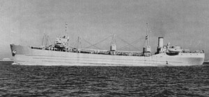
Steel had become scarce during World War I and the Second World War was again consuming the country's steel resources. In 1942, the U.S. Maritime Commission contracted McCloskey & Company of Philadelphia, PA to build a fleet of 24 self-propelled dry bulk cargo concrete ships. Improvements in concrete technology made this fleet lighter and stronger than its WWI predecessors.

S.S. Arthur Newell Talbot (in her prime years)

The ships, named after pioneers in the science and development of concrete, were constructed in Tampa, FL starting in July of 1943. The identical ships were built at an incredible rate, with one being launched a month.  Two of the ships were sunk as block ships in the Allied invasion of Normandy. Nine more were partially sunk in December 1948 to form a breakwater for a ferry landing at Kiptopeke, VA. This group of ships, affectionately known as “Kiptopeke’s Navy,” includes the S.S. John Grant, S.S. Robert Whitman Lesley, S.S. William Foster Cowham, S.S. Richard Meade, S.S. Willard A. Pollard, S.S. Willis A. Slater, S.S. Arthur Newell Talbot, S.S. Edward Thatcher, and S.S Leonard Chase Wason.  (Several other surviving concrete ships serve as breakwater in Newport, Oregon and along the Powell River in British Columbia.)  After the completion of the Chesapeake Bay Bridge Tunnel in 1964, the ferry was no longer needed. Now the ships protect the beach at Kiptopeke State Park and serve as a habitat for marine life and birds. There were flocks of sea gulls congregating on the mustard- and rust-colored hulks and plenty of pelicans raiding the fish net traps that run from the south end of the breakwater to the shore.

Two of “Kiptopeke’s Navy” today


We dropped anchor behind the southern end of the breakwater and were joined a short time later by three sailboats.  After several days of oppressive heat we were pleasantly surprised (and chilled) by today’s 75° temperature.  The anchorage, recommended to us by Gustav and Charlotte on Ida Rose, was not very well protected from the north winds or from the wakes of the commercial vessels cruising the bay.  Perhaps, after many years of sailing on the North Sea near their home in Rotterdam, Kiptopeke seemed calm!  We settled in for a lumpy evening.  My new “smart” phone said we were in Houston, TX…


June 15, 2011 –Lazy W takes a beating on the bay

The morning was a breezy one and Lazy W bobbed lazily but securely tethered to her anchor.  The forecast called for more windy conditions, and thinking that Kiptopeke offered little protection, we decided to head out and make our way 46 miles north to Onancock where we would meet up with Patti and Alan on Fairways.  The anchor came up smoothly and by 9AM we were on our way.  The bay was choppy and full of white caps from a brisk north wind.  After half an hour we toyed with the idea of heading back to Kiptopeke but pressed north instead.  Why?  Because we did not think it was a protected anchorage in the north winds but we heard later on that the winds had been gusting to 19 knots there!!  We had been protected and didn’t realize it.  We should have stayed…

We took quite a beating from the relentless waves of 3-4 feet.  Occasionally a wave broke over the bow, flipped the table on the rear deck, battered the dinghy which lost its fender pad and now clanged against the davits.  Down below, things were not faring much better – hours later when the wind calmed down, I went down to discover that the floor in the forward cabin had come up, the salon furniture had shifted to port, the tower fan and bench had bounced down the steps into our cabin, books were strewn helter skelter – the place appeared to have been ransacked!

We arrived in Onancock Creek about 3:30 and the previous hour or so had been relatively calmer that the first few.  We wound our way up the creek to Onancock Wharf where we wedged the boat into a very narrow slip with a short finger pier.  It did not take long to realize that with this configuration we could not get off the boat (and believe me, I so needed to get off!) so we squeezed back out and went to anchor just off the wharf entrance amid four sailboats.  This was not a good time for the anchor to be uncooperative, but it was.  Somehow as we were beating our way through the waves, the anchor chain got tangled in the locker and now refused to come out.  I ran down to detangle it while Frank held the boat in position.  By the time I returned to the deck I was a bit frazzled and could not remove the U-bolt securing the chain.  We swapped positions.  Frank got the bolt off while I manned the helm.  We swapped positions again.  The anchor chain eventually cooperated and Frank set the anchor.  It was now 4:30.  We both needed a drink...
 
The Onancock Wharf from an anchored Lazy W

After a calming glass of wine and reassuring ourselves that Lazy W was securely anchored, we lowered the dinghy and made our way to the wharf for drinks on Fairways and a wonderful dinner at the Blarney Stone Pub. 

During our many travels by car up Route 13 through the Eastern Shore we always saw directional signs for Onancock but never had the time to stop in as we were on our way to someplace else.  We are glad we got the chance to stop here by boat and enjoy its small town charm.  Sitting on the wharf is the restored Hopkins & Brothers Store dating from 1842. Four generations of the Hopkins family ran the store through the height of the sail and steamboat eras.  While it is now home to Mallards at the Wharf restaurant, you can still get a sense of the old-time store as you walk to the dining room past empty penny-candy jars tucked behind the original massive wooden counters.  Old metal advertisement plaques adorn the walls in the store area and photos of a bustling port from a bygone era decorate the dining room. Top off a delicious waterfront meal, perhaps prepared by Johnny Mo - the Musical Chef, with a decadent slice of eleven-layer Smith Island Cake, Maryland’s State Dessert. 
 
And back behind the dockmaster’s office, the local gentlemen hang out and shoot the breeze on the Liar’s Bench...

Early the next day while inspecting the dinghy davits Frank found some broken bolt heads on the swim platform – they had been securing one of the four davit arms to the aft of Lazy W and must have been victims of the beating we took on the bay.  An immediate repair was necessary so, after drilling out the broken bolts, we dinghied to shore and pedaled up Market Street on borrowed bikes in search of stainless steel replacements.  Much to our surprise we found exactly what was needed and repairs were sufficiently - but not fully - made by early afternoon.  Thunderstorms rolled in that evening and a wakeful night was spent on the hook.

Next morning, while Fairways headed east to Mobjack Bay, we pointed Lazy W north to Crisfield, the self-proclaimed Crab Capital of the World.  It has been ten years since we first brought Sea Venture, our 37-foot Mainship, into Crisfield and the economic downturn and the years since have not been kind to this town.  Many storefronts are empty, the 500+ slip Somers Cove Marina is less than half full, and the Captain’s Galley Restaurant that was a local favorite has been torn down and replaced with waterfront condos.  But we are on a nice new floating dock that is a quick walk to The Ice Cream Gallery!  Happy hour and dinner on the boat in a marina that is so quiet it is almost like being at anchor – not a bad way to spend a Friday evening.

Our next planned stop on our journey north was at Wikander’s Yacht Yard on Wicomico Creek in Allen, MD.  WYY is owned by Stu Wikander, a high school/college buddy of Frank, and his wife Carol.  The Wicomico River snakes through marshy countryside and farmland and, after 22 miles, reaches the town of Salisbury, the hub of the Eastern Shore.  We would only travel the first five miles or so before heading up the creek. As soon as we passed Nanticoke Point we were inundated with brown flies intent on nibbling on our arms and ankles.  A few miles upstream at the town of Whitehaven we encountered a 3-car cable ferry crossing the river.  As we neared WYY, a bald eagle, a turkey vulture and an osprey were engaged in some sort of neighborhood disagreement.  Carol met us at the floating dock and we were safely tied up by 12:30 after a four hour journey from Crisfield, a mere 25-mile trip via car or 33 nautical miles via Lazy W!  Later that afternoon, Stu and Carol joined us for happy hour aboard the boat; we wrapped up the day with great food and conversation at Fratelli’s Restaurant in Salisbury.

 
 Wikander’s Yacht Yard from Lazy W

Stu and Frank spent a rainy Father’s Day afternoon completing the repairs to our dinghy davits.  Thanks to Stu’s presence, I did not have to lay on the narrow swim platform wrestling with the loose davits while Frank drilled new screw holes for a more secure attachment.  Thank you, Stu!  Our gracious hosts invited us to share dinner with them and their children, Meghan and Timothy, and Meghan’s friend, Travis. 

We made preparations to leave WYY early Monday morning to take advantage of tide and currents.  However, the weather was not cooperative – with a marine forecast of winds blowing NE at 15 knots, gusting to 25 knots we decided to stay put one more day...


Monday, June 13, 2011

SO, WHAT DOES THE INSIDE OF A 43' BOAT LOOK LIKE?

This is the forward crew cabin.

My small but functional galley with a good-sized black refrigerator on the right.

A view of the main salon from the aft entry steps. 
The galley is tucked away down a few steps located to the right of the table. 
 The crew cabin is forward of the galley.

A view of the main salon from the galley end.
The Captain's cabin is down a few steps to the right of the stool at the computer desk (aka our office).

The seating area of the main salon.

The aft Captain's cabin.

The cabinetry on the port side (better known as the Admiral's side!) of the Captain's cabin - there is matching cabinetry on the starboard side for Frank.

As you can see, the boat is airy and compact - but extremely functional with all the modern comforts of home.  Lazy W has been our home since April 2010 and since that time her interior has been redecorated to suit our comfort needs.